Drakensberg Passes | Ifidi Pass
Region: Mnweni area, Northern KZN Drakensberg
Distance from the parking to the top: 21 km
Difficulty: Extreme (9/10)*
Scenery: Stunning!
Route type: ROCK
Risks: Difficult scrambling and boulder hopping, exposed in places, no trail, flash-flooding.
It is recommended that this pass is not attempted during or immediately after heavy rain.
*Most Drakensberg passes fall into the extreme difficulty category. To differentiate the “easy” ones from the harder ones, a rating out of 10 is included after the extreme rating. For more information, see the Drakensberg Passes Intro article.
 Boulder hopping along the lower section of Ifidi Pass.
Introduction
Ifidi Pass is the first in the procession of impressive routes in the Mnweni area — arguably one of the most dramatic regions of the uKhahlamba-Drakensberg range. The passes here are all above-average in difficulty due to the rugged terrain, remoteness, and long approaches to their bases.
Ifidi and its neighbouring Icidi Pass have reputations as two of the toughest challenges in the Berg. Classified as a ROCK pass, Ifidi involves sustained scrambling and may require teamwork to pass backpacks up some steeper sections. While it doesn’t demand true climbing, it does call for care, good judgement, and competent partners. Carry at least 5 m of rope for pack-hauling.
 Passing below the magnificent Ifidi Pinnacles.
Getting There
The hike begins at the Mnweni Cultural Centre. Refer to Introduction to Mnweni for more information about the area and access logistics.
Mnweni Cultural Centre to Basecamp (14 km)
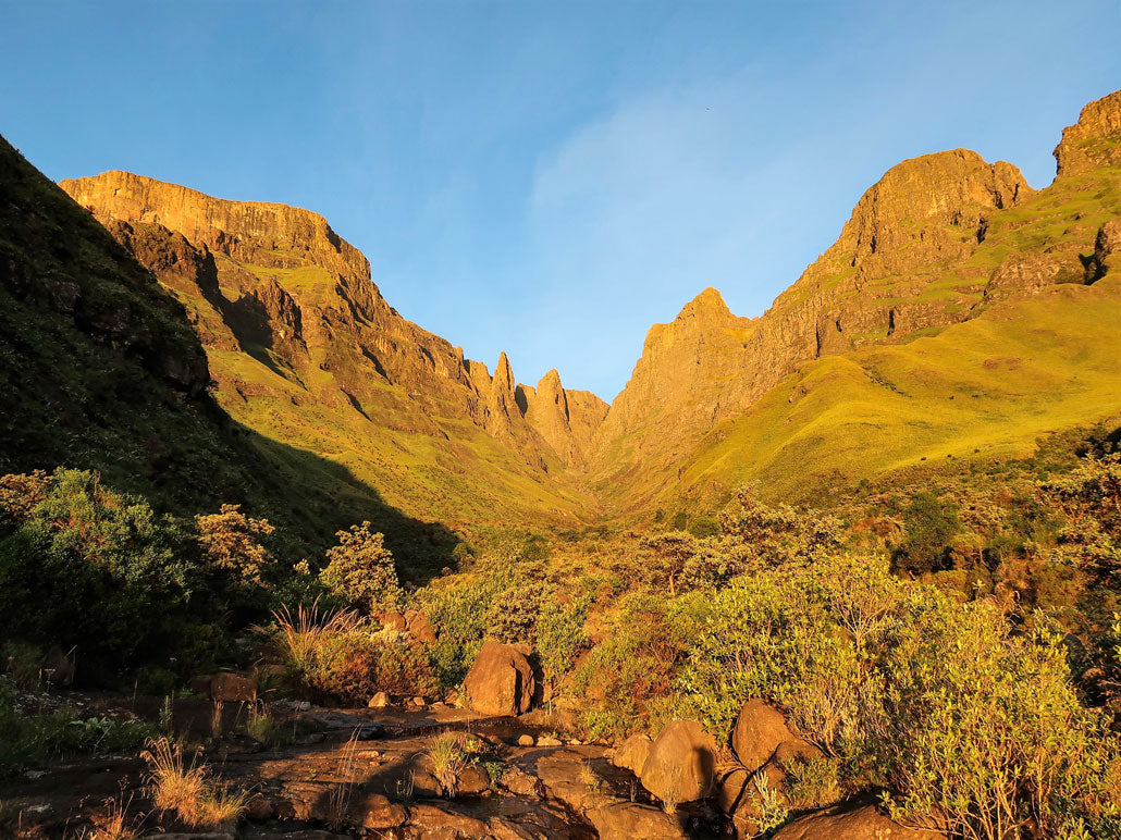
From the Cultural Centre, the imposing cliffs and passes of the Mnweni Cutback dominate the view to the west. The Devil’s Tooth stands as a sharp landmark, while the first major pass south of it — rising steeply into Lesotho — is the deeply incised valley of Ifidi Pass.
 Following the approach road toward the Mnweni Cutback.
Follow the dirt road past the centre until it crosses the Mnweni River via one of the newer bridges (note that maps of the area are outdated — several new roads exist). Stay on the northern bank path, taking the right fork at the confluence of the Mnweni and Ifidi Rivers to head up the Ifidi Valley.
While the map suggests remaining on the right-hand side of the valley, a new dirt road on the southern bank offers an alternative approach. Either route works. Expect to cross at least one barbed-wire fence used to divide grazing land. Near the base of the pass, find the trail that turns northwest into the forest guarding the narrow entrance to Ifidi Pass.
 It’s always a delight to hike in the high foothills of Mnweni.
Passing through the forest on a faint trail feels almost like the old-growth woods of the Amatolas. Cycad Cave (a small overhang) marks the usual basecamp, though it’s frequently used by cannabis traders and can be dirty. A better option is to continue past a few small trees to a grassy slope with unobstructed mountain views and good campsites. In fine weather, one can even sleep on flat rock slabs beside the river — provided water levels are low.
 Flat rock slabs make for excellent star-gazing bivvy spots in good weather.
 A magnificent sunrise when camping beyond Cycad Cave.
Basecamp to the Escarpment (7 km)
Many route descriptions recommend boulder-hopping up the riverbed past Cycad Cave. However, a faint trail continues above the southern grassy banks, saving time and adding variety. The trail isn’t well-trodden but may be visible after recent burns.
 Trail finding on steep grassy slopes above the river.
The path is steep and sometimes exposed, especially where it traverses above a waterfall. A slip here could be serious — descend to the river if you’re not confident. The trail eventually rejoins the riverbed, giving access to the final steep gully. The initial section is overgrown, but the vegetation soon clears, revealing a narrowing boulder-strewn channel framed by the towering Ifidi Pinnacles.
 Walking past scorched cycads — some already pushing out new leaves.
 The gully split below the Ifidi Pinnacles — take the right-hand fork.
The final 400 m ascent involves steep boulder hopping and short scrambles where packs may need to be passed up. The gully narrows to just a few metres, and heavy rain poses a flash-flood risk. Proceed only in stable weather.
 The final gully — steep, narrow, and unrelenting.
Camping on the Escarpment
There’s plenty of camping space on the escarpment. Your overnight spot will depend mainly on your onward route or descent choice. Water is generally available near the top of the pass.
Essential Gear
A short rope (5 m) for pack-hauling is highly recommended. Otherwise, standard Drakensberg gear applies — sturdy boots, warm layers, navigation tools, and reliable weather protection.
 Reaching the escarpment — the reward after a long, demanding climb.